*Post written by Mona Meyer, Archives and Special Collections Metadata Librarian.
The capital of Indiana wasn’t always Indianapolis. Hopefully, if you are from Indiana or have lived here for a while, you know this, but you may be a stranger to these shores and thus unaware of this fact.

First, there’s the question of Indiana as a territory vs. Indiana as a state. The land mass we now know as Indiana was, after the Revolutionary War, part of the Northwest Territory, established in 1787. A vast area of over 260,000 square miles, the Northwest Territory was everything west of Pennsylvania, north of the Ohio River, east of the Mississippi River, and south of the Great Lakes.

As the population grew, different areas split off. In 1800 the western portion became known as the Indiana Territory, with William Henry Harrison as its governor. The capital of the Indiana Territory was Vincennes.
This “Red House” was built in 1805 as a tailor shop, and was used as the territorial capitol building. The Senate met upstairs and the House on the first floor. This timber frame building is held together with wooden pegs.
Vincennes existed long before either the Northwest or Indiana territories came into existence. In the early days of exploration of the American continent, this area was hotly contested between the French, British, and Native Americans. At stake was the rich fur trade. “Vincennes was founded in 1732 by Francois Marie Bissot–Sieur de Vincennes, a French military officer. This area was part of New France and the military post was built on the Wabash River to protect the rich fur trade here from the British. When the fur trade died out, this area turned to agriculture. This military post became the oldest continuous settlement making Vincennes the oldest town of Indiana.”

After 7 years (1754–63) of fighting in the French and Indian War, the British came out on top. In the Treaty of Paris, “Great Britain secured significant territorial gains in North America, including all French territory east of the Mississippi river, as well as Spanish Florida, although the treaty returned Cuba to Spain.” The British victory was not long-lived, however. During the subsequent American Revolution, a Virginian named George Rogers Clark seized control of Ft. Sackville in Vincennes. On February 25, 1779 an American flag was raised over the fort for the first time.

This is the George Rogers Clark Memorial in Vincennes. Fort Sackville was on this approximate site.
Even before Indiana was granted statehood, the issue of where the capital should be arose. After the Illinois Territory split off, Vincennes was no longer central, but on the western fringes. Lawrenceburg, Vevay, Madison, Corydon, Salem, and Jeffersonville all vied for the honor. But wait, you say—those towns are all in southern Indiana and thus not central, either. For population to grow, settlers need to be able to travel to the area. Much transportation in the early 1800s was by water, and all the contending towns (except Salem) are located on the Ohio River. They were not central in terms of the area of Indiana, but were central in terms of population. “In 1813, with John Gibson as acting Governor, the Assembly took up the matter. The House of Representatives favored Madison but the Council would not agree and Corydon was chosen in conference. The [State Capital Act] which was dated March 11, 1813, was to be effective by May 1, 1813.”

Corydon was always intended as a temporary capital. Roads were being built that facilitated northern migration, and in 1821 the city of Indianapolis was founded to become the final state capital for Indiana. Indianapolis was but a frontier city at the time the capital was moved, although its official designation as the capital, in addition to improved access via the National Road, caused it to begin to grow. The actual move took place in 1825, very slowly, since Corydon was then an 11-day journey from Indianapolis!


For all its splendor and homage to the Parthenon, the building did not last long. This style fell out of favor after the Civil War, but what is worse is that the edifice itself was deteriorating. “By the 1860s the soft blue limestone foundation was failing, and the stucco was chipping off, causing one local historian to call its appearance “disgusting.” In 1867 the ceiling in the Representative Hall collapsed. After an 1873 Statehouse Committee in the General Assembly failed to find a solution to the structural problems, it was only a few years before the Capitol was condemned and demolished.”
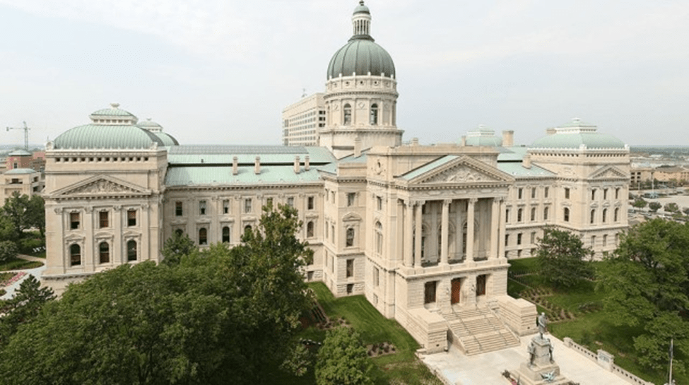
The competition to design a new capitol was won by Indianapolis architect Edwin May. “May titled his design Lucidus Ordo, Latin for “clear arrangement.” Shaped like a Greek cross, the structure featured a central dome and rotunda. The main floor was built fourteen feet above ground level, and it held the governor’s and other executive and administrative offices. On the second floor, May located the chamber for the House of Representatives on the east, balanced by the Senate chamber on the west. Offices and other rooms surrounded the open atriums, and the Indiana Supreme Court was located in the north end. The interior was designed in the style of the Italian Renaissance. Whenever possible, the plan called for Indiana materials. For instance, wainscoting, doors, and trim were made of Indiana oak, maple, and walnut. … The exterior of the building reflects the Italian Renaissance Revival style with the large central dome and corner pavilions topped with low domes. The limestone facades include Neo-Classical elements, especially in the Greek temple style entries. Here too, the architect used Indiana materials. The walls were constructed of brick, covered with oolitic limestone quarried from Monroe, Lawrence and Owen counties. The foundation of blue limestone came from quarries near Greensburg and North Vernon. Workers laid the cornerstone, a ten-ton block of limestone from Spencer, Indiana, on September 28, 1880. Its inscription read simply “AD 1880.” Placed within the cornerstone were forty-two different items. They included annual reports from various government agencies; a Bible; forty-seven varieties of cereal and vegetable seeds grown in Indiana, “incased in small glass cylinders, hermetically sealed”; new coins; maps and newspapers; a history of Indianapolis; and pamphlets from various institutions in the city.” After many trials, including the death of the original architect, the capitol was completed and open for business in 1888, actually coming in on budget.

Since its inception as a territory in 1800, statehood in 1816, and the 1825 move to Indianapolis, Indiana has had 3 locations for its capital, and the government met in 4 permanent structures, not to mention all the meetings in temporary locations. The answer to the question, “what is the capital of Indiana?” isn’t always a simple answer!
Resources Consulted:
French and Indian War/Seven Years’ War, 1754–63 (Office of the [U.S.] Historian)
Indiana Historical Bureau—The State Capital Act, 1813
Indiana Historical Bureau—225th Anniversary Exhibit
Indiana Historical Bureau—Why Statehood?
Indiana State Museum: Corydon Capitol
Northwest Territory (Encyclopedia. com)


Leave a comment