*Post written by Mona Meyer, Archives and Special Collections Metadata Librarian.
Samuel Taylor Coleridge penned this in The Rime of the Ancient Mariner, but I’m going to co-opt it for this blog about the 1937 flood of the Ohio River. You may be thinking, oh, no, not another article about Evansville and the flood … and you’d be right! I’m going to focus on other locations, and there won’t be much text, concentrating on telling the story visually with some explanations.

The Ohio River is 981 miles long, beginning in Pittsburgh, PA where the Monongahela and Allegheny Rivers meet, and it ends in Cairo, IL where it empties into the Mississippi River. In January 1937 there were torrential rains. There were about 14 inches of rain in Cincinnati, nearly 15 in Evansville, and almost 20 in Louisville. “Overall, total precipitation for January was four times its normal amount in the areas surrounding the river. In fact, there were only eight days in January when the Louisville station recorded no rain. These heavy rains, coupled with an already swollen river, caused a rapid rise in the river’s level.” Flooding was inevitable.
Everyone knows that water flows downstream, so the Ohio River thus flows northeast to southwest. The unusual thing about this flood is the way or order in which the various tributaries flooded and thus contributed to the flooding of the Ohio. The tributaries on the lower Ohio (i.e., those nearer the mouth of the river in Cairo, IL) flooded earlier than those near the headwaters in Pittsburgh dd, giving the odd appearance that the flood moved from the mouth (near Cairo, IL) to the headwaters (Pittsburgh, PA). This was not true, but that is how it appeared, and this is how we’re going to take a look at the pictures.
Let’s head back to 1937 and up the river!

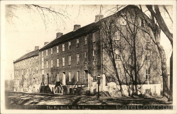
Black school in Shawneetown, IL, February 6, 1937. Source: UASC, MSS 272-0034. 
Home of Nellie and Roy Hape near Dam 49 in Uniontown, KY, with a house floating in front, 1937. Source: UASC, MSS 272-0927. 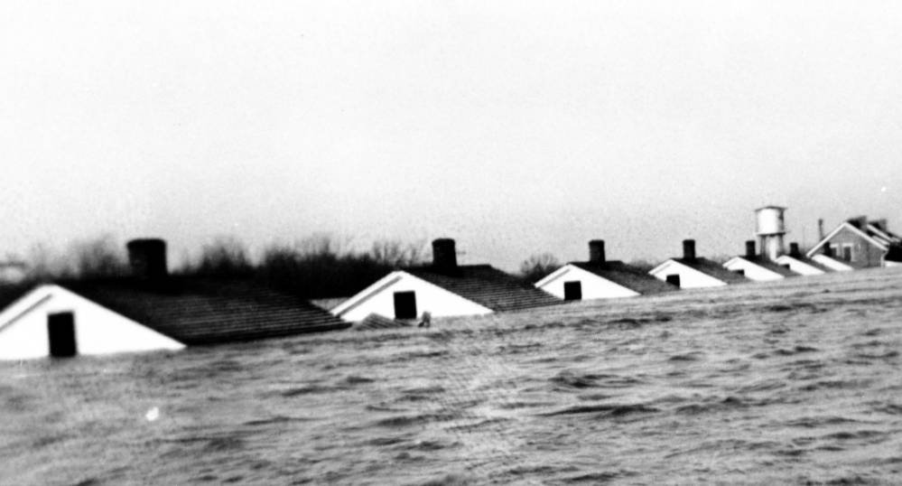
Row of houses, almost completely submerged, near tower by Dam 49 in Uniontown, KY, 1937. Source: UASC, MSS 272-0908. 
Sherburne Park at 151 West Water Street, Mt Vernon, IN bandstand under water. Barge and steamboat in background, 1937. Source: UASC, MSS 272-0251. 
Same scene in Mt. Vernon, IN, with rescue trucks and boats ready. Source: UASC, MSS 272-0254. 
Railroad tracks warped and twisted by the flood, Mt. Vernon, IN, 1937. Source: UASC, MSS 272-0245.
Sometimes the aftermath of the flood had ironic consequences, such as this picture of a mule pulling a car! At other times, there was pathos – a family’s ruined belongings, possibly even family heirlooms, piled up by a shed.

Mule driven wagon pulling car through field in Posey County, IN. Source: UASC, MSS 272-0265. 
Flood damaged items stacked by corner of shed or barn, in Posey County, IN. Source: UASC, MSS 272-0266.
Skipping Evansville, we now come to Henderson. While the low-lying areas around the town certainly suffered flooding devastation, the city itself held the distinction of being the only town along the river without water within its city limits. As of “Feb. 1, … Henderson was safe and dry. Utilities were working, refugees were being housed, food was well supplied and businesses continued to operate, some of them around the clock. “Our visitors are well-fed and well entertained,” The Gleaner reported the next day. “Thousands of toys have been given to the children, and games and magazines have been distributed to the adults. We are just one big family, thankful that our forefathers selected the highest point on the Ohio River for our homes.”” Just because the city itself wasn’t flooded didn’t mean it got off scot-free. The bridge across the river flooded and was unavailable for a period of time. Trains could not get through. Getting in and out of Henderson meant a circuitous route “via Zion, Niagara, Robards, Dixon, Slaughters, Hanson and Madisonville.” Water availability was lost twice and residents were ordered to boil all water. Finally, through the generosity of Hendersonians, there were 16 refugee camps within the city, but this brought its own challenges. “At least 2,649 refugees were housed here temporarily increasing Henderson’s population by about 22 percent so diseases such as typhoid fever, scarlet fever and influenza were a very real concern. At least 33,000 vaccinations were administered locally. Mandatory immunization for typhoid fever was done on all refugees, and vaccines were also provided by the U.S. Public Health Service for tetanus, diphtheria and smallpox. At least nine people with scarlet fever were quarantined, as of mid-February, and 7-year-old Reba Daugherty died of it.“

The Ohio River crests near the foot of Water Street in Henderson, KY during the flood of 1937. Photo courtesy of George H. Warren/From the Maclean Dameron Collection at Martin Studio. Source: https://bit.ly/3pZwb6t 
Dam 47 powerhouse building on riverfront in Newburgh, IN. Photograph taken from river looking back at building. Source: UASC, MSS 272-0093. 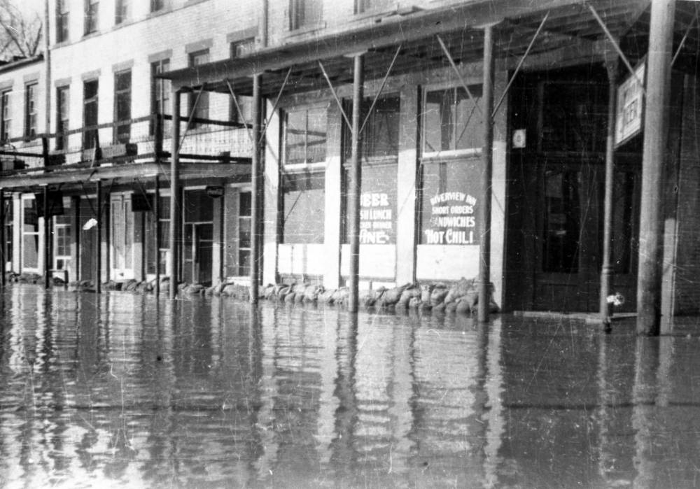
Street flooded in front of Riverview Inn with sandbags in front of the inn, at the corner of Water and State Streets (no longer standing), in Newburgh, IN. Source: UASC, MSS 304-009. 
Side view of American Legion Hall at 1st and St. Ann Streets in Owensboro, KY. Source: UASC, MSS 272-0099. 
In Grandview, IN, the switchboard of the Indiana Bell Telephone Company, in this house, was threatened by floodwaters. Source: UASC, MSS 264-2604. 
In the event that the water did get into the building, the switchboard and operator were moved atop a tall platform in Grandview, IN. Source: UASC, MSS 264-2603. 
The Tell City, IN Planing Mill and neighboring buildings in deep flood water. The wooden picket fence disappears into water. There may have been a filling station near the mill, as evidenced by what appear to be barely visible pumps. Source: UASC, MSS 272-1076. 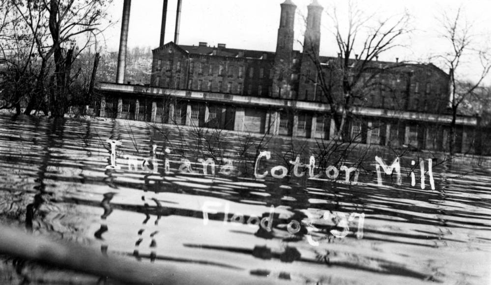
Cannelton Cotton Mill, also known as the Indiana Cotton Mill at 310 Washington Street in Cannelton, IN. Source: UASC, MSS 272-1061.
The small town (2010 Census: 238) of Leavenworth, IN was laid out in 1818 on the banks of an oxbow bend in the Ohio River, below the bluff. The picture below is ample evidence for why the entire town, in 1938, moved to a location atop the bluff, although there are still some businesses in the lower town. I’m NOT a paid spokesperson for them and will not be compensated for this, but a trip to Leavenworth and a meal at the Overlook Inn are well worth your time. The food is good, and the views of that oxbow bend from atop the bluff are spectacular.

Leavenworth, IN, 1:40 p.m., February 2, 1937. Source: UASC, MSS 2472-1166. 
East Spring Street near Jay Street in New Albany, IN on February 4, 1937 after the water was held by the flood gates. Source: UASC, MSS 272-0010.
This photograph from New Albany, IN demonstrates just how “capricious” a flood can be. Note the homes in the foreground are not in water, but those in the background are, as evidenced by the house in the middle of the street that has come off its foundation. Furthermore, merely one block away from this view of Spring and Jay, the water at Spring Street and Silver Street just touched the bottom of the traffic signal there at the January 27 cresting of the flood water.

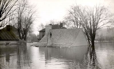
Destroyed house. This residence has been lifted off its foundation, in Jeffersonville, IN. Source: UASC, MSS 272-0286. 
Florist shop completely removed from its foundation and redeposited in someone’s front yard, in Jeffersonville, IN. Source: UASC, MSS 272-0288.

West end of Louisville, KY on January 27, 1937. Source: https://bit.ly/3BIadHp 
L & N Railroad freight yards no. 6 on January 9, 1937, in Louisville, KY. Source: UASC, MSS 272-0008. 
Not too many trains were going in and out of Union Terminal in Cincinnati, OH, in January 1937. This building today serves as the home of the Cincinnati Museum Center. Source: https://bit.ly/3mEEeTV 
Nor would there have been many planes taking off and landing from Lunken Airport or Lunken Field in Cincinnati, OH on February 2, 1937. Some references refer to this as “Sunken Lunken.” Today it serves private and corporate flights. Source: https://bit.ly/3mFmxne 
Looking into flooded Crosley Field, the home of the Cincinnati Reds from 1912 to 1970, in Cincinnati, OH. It was under 21 feet of water. Too bad the Reds weren’t a water polo team. Source: https://bit.ly/31mm5SJ 
The John A. Roebling suspension bridge between Cincinnati, OH and Covington, KY. Notice how close the deck is to the water. This was the only bridge open for the entirety of the flood from Pittsburgh, PA to Cairo, IL. Source: https://bit.ly/3waMjTw
Getting near the end of our trip now … just a couple of pictures from West Virginia and finally Pittsburgh, PA where the river begins, and the flood ended.

Third Avenue, west end of Huntington, WV, January 28, 1937. Source: https://bit.ly/3BGSr7a 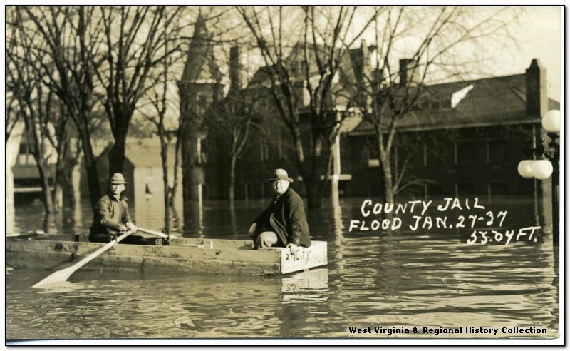
Rescue boat near Wood County jail in Parkersburg, WV January 27, 1937. Source: https://bit.ly/3mGvLQo 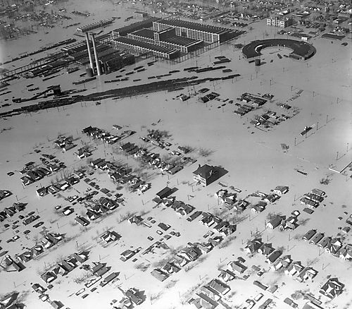
Pittsburgh, PA, February 25, 1937. Source: https://bit.ly/2ZWQU03
The flooding on the Ohio River caused its tributaries to back up, causing flooding in places like Hazleton, IN and Patoka, IN that aren’t near the banks of the Ohio. Advances in engineering, etc. have given us a better handle on flood control, rendering another flood of this magnitude unlikely. Still, never say never to Mother Nature!

Resources Consulted
“A Business Survey of the Flood.” Barron’s, February 1, 1937, Vol. 17(5), p. 9.
Eleven Days of Rain: the Ohio River Valley Flood of 1937. January 12, 2020. Orangebeanindiana.com
Flooding History in Louisville. Louisville MSD
The Floods. ExploreNewAlbany.com
The Great Flood of 1937. National Weather Service (Louisville, KY office)
Historic Ohio River Flood of 1937. National Weather Service (Wilmington, OH office)
Noble, Greg. From The Vault: Great Ohio River flood of 1937 was biggest event in Tri-State history. WPCO, Cincinnati ABC affiliate, January 25, 2018.University of Pittsburgh Library Systems Digital Collection


Leave a comment